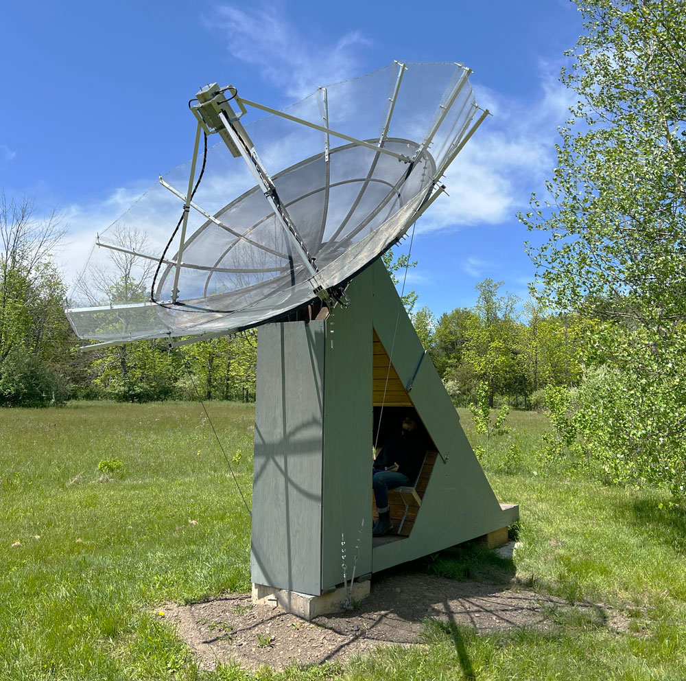
Here GOES Radiotelescope is an artist-run DIY ground station receiving GOES-19's faint, data-dense GRB transmission, and is one of the first independent stations to do so.
Visitors to the sculptural station sit within it and look through the “telescope” and see images of the Earth as they are being received from the satellite—from the seat, we effectively see ourselves through the satellite’s eyes.
GOES-19
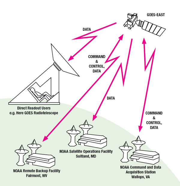
GOES-19 is one of NOAA’s flagship satellites that gather data for monitoring and predicting weather on Earth. Also known as GOES-East, it is positioned at a longitude far above the East Coast of the United States.
GOES-19 is about the size of a school bus with a large solar panel wing, is orbiting Earth about 22,000 miles away from its surface at a speed which matches the Earth’s spin. Its stationary nature in orbit relative to the Earth enables static structures on Earth’s surface to be in direct relationship with the satellite. Here GOES Radiotelescope’s dish is fixed and pointed directly at the satellite, which is 41-degrees above the horizon at Wave Farm in Acra, New York, to receive the faint radio signal.
GOES-19's CAMERA
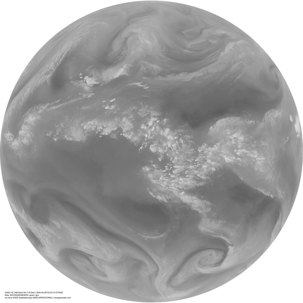
Its primary instrument, the Advanced Baseline Imager (ABI), takes pictures of four areas: the entirety of the Western Hemisphere, the United States and its neighbors, and two cropped sections that are adjusted to follow the latest weather developments. The detectors on the ABI collect image data at particular wavelengths that are sensitive to different aspects of the landscape’s weather such as ozone, carbon dioxide, water vapor, snow, vegetation, and wildfires.The initial images seen through Here GOES Radiotelescope are greyscale; they are individual spectral bands and are used in combination to evaluate conditions. For color images, after reception some of the bands are combined into single images of the Earth emulating the range of wavelengths that the human eye would see from space, “true color” pictures. GOES-19 also collects and transmits data for mapping lightning events and space weather—energy and particle output from the sun which can damage satellites and electrical grids on Earth.
SOUND
The sound heard onsite at Here GOES Radiotelescope is a ‘sonification’ created from space weather data collected in real time by Here GOES Radiotelescope. It is an audio imagining of the soundscape of solar wind hitting and flowing around Earth, as if it were a field recording of the interaction of energies. Read more and listen here.
ALL OF THE DATA
Here GOES Radiotelescope receives the ‘GOES ReBroadcast’ (GRB) stream of data. This stream contains the full suite of the data from all the instruments aboard the satellite and Here GOES Radiotelescope is one of the first independent stations in the world to do so. The main users of GRB outside NOAA itself are other government agencies such as the Air Force and Navy, research institutions such as CIRA (Cooperative Institute for Research in the Atmosphere at Colorado State University) and SSEC (Space Science and Engineering Center at the University of Wisconsin-Madison), and private companies who have an interest in original weather source data, such as Accuweather for the business of forecasting, and Boeing for aerospace activities.
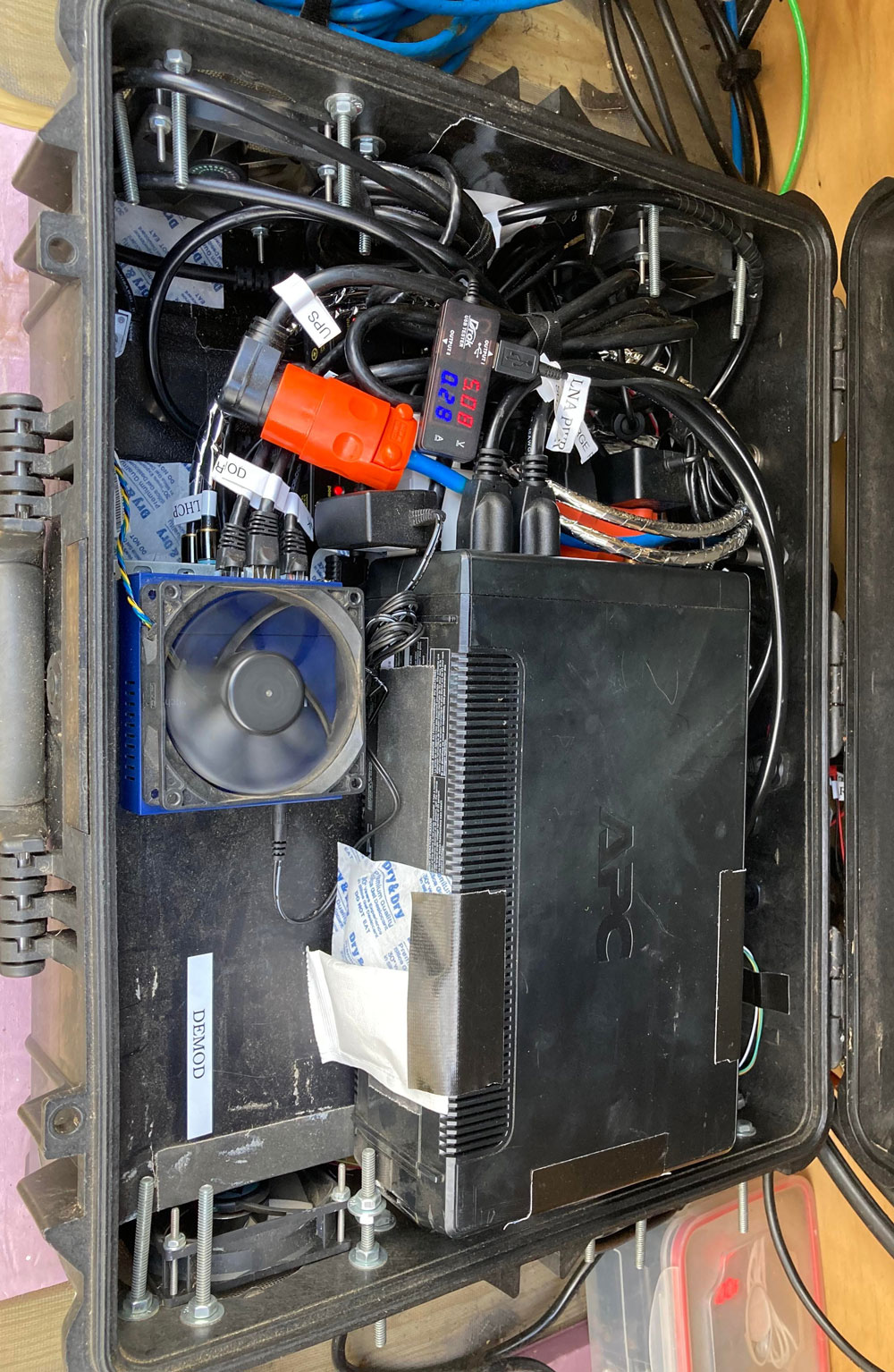
Here GOES Radiotelescope uses off-the-shelf electronics and equipment and freely available software to receive GRB including radio tuner cards for TV satellite reception, a second-hand windows computer (purchased on eBay from a community college in Nebraska), a dish feed made by an amateur radio parts manufacturer in the Netherlands, and a large satellite dish augmented by wire material usually used to house guinea pigs. Here GOES Radiotelescope was built and operates on a small fraction of a typical budget for a corporate or government ground station.
GRB from GOES-19 produces a lot of rich data. Each full-disk Earth image received from the camera is up to 21,696 pixels across and up to about 350 megabytes, and arrives every 10 minutes. The combination of multiple instruments and multiple views in the data stream means that Here GOES Radiotelescope and other ground stations receiving the GRB collect about 1 terabyte of data per day.
Since this would rapidly fill the on-site station-operating computer, Here GOES Radiotelescope compresses and uploads a portion of the data to online storage, which serves as a data archive for related art projects. A selection of the images received in the last 24-hours is available for exploration and download from this website. The most recently viewed images through Here GOES Radiotelescope's viewport are under 'Images|Now,' and those from the last 24 hours are in 'Images|Then.'
WHY
Here GOES Radiotelescope creates an avenue for individuals to directly relate to the usually invisible infrastructure we rely on. Seeing the image stream and hearing data from GOES-19’s constant radio transmission is a reminder of the ubiquitous invisible radio data surrounding us, and how much we rely on our orbiting infrastructure and these streams for weather forecasting, navigation, communication, and many other services.
By receiving the data stream as individuals, we participate directly in the activities in Earth’s orbit and are reminded that such unmediated participation is possible. Visitors sitting in the physical Here GOES Radiotelescope structure are placed in direct positional alignment with the satellite, making the distant spacecraft relate to our bodies and the landscape we inhabit; we see the wide view of the full Earth from space, and can intuit our place on it.
Heidi Neilson (heidineilson.com) is an interdisciplinary artist interested in the connections between people on the ground and off-planet conditions and infrastructure.
R. Dove (wx-star.com) is an engineer working on low-latency processing algorithms for satellite remote sensing.
The artists first connected in 2017 in an online forum for DIY weather satellite image transmissions. They are collaborating on Here GOES Radiotelescope to further interest and participation in extraterrestrial radio reception.
Many thanks to Lucas Teske and the Open Satellite Project chat room for inspiration and open-source software development; Brett Casebolt (@BrettCasebolt / naturalgfx.com) for developing and providing GRB Streamer, the software that enables low-cost demodulation of the GRB signal; the CSPP team at the University of Wisconsin-Madison for developing CSPP GEO, software used to recover GRB payloads from CADU streams; SPACES (Cleveland, OH) for initial support and launch of the early project iteration; and to Galen Joseph-Hunter, Kim Fisher, JF Mergen, and Jennifer Dove for helping with troubleshooting in many forms. And a resounding THANKS to Wave Farm for providing Here GOES Radiotelescope a happy home.
Wave Farm (wavefarm.org) is a non-profit arts organization driven by experimentation with broadcast media and the airwaves. Our programs—Transmission Arts, WGXC-FM, and Media Arts Grants—provide access to transmission technologies and support artists and organizations that engage with media as an art form. Wave Farm programs are made possible, with significant support from the New York State Council on the Arts with the support of Governor Andrew Cuomo and the New York State Legislature; the National Endowment for the Arts; and the Greene County Legislature through the County Initiative Program, administered in Greene County by the Greene County Council on the Arts (aka CREATE). In addition, special thanks are due to Dan Braverman and Radio Systems, Inc. for making this project possible.